 Geodaten Deutschland v.18.01
Advertisement
Description
The database tables contains geodata of the Federal Republic of Germany with geo referenced towns, municipalities, town quarters and other administrative units, postal codes, telephone preselections, nature areas, landscapes, climatic zones and official topographical cartographies. The data contain coordinates for navigation and geo-coding, proximity searches and distance computations and are prepered for the spatial mapping of environmental...
Read more
- Rate:
- Release Date:05/23/2014
- License:Data Only
- Category:Database Solutions
- Developer:C. Killet Software Ing.-GbR
- Downloads:1603
- Size:1.79 Mb
- Price: $205.00
To free download a trial version of Geodaten Deutschland, click here
To buy software Geodaten Deutschland, click here
To visit developer homepage of Geodaten Deutschland, click here
Advertisement
Versions History
| Version | Date Released | Release Notes |
| 18.01 | 23.05.2014 | Datenstand auf den 1. Januar 2014 aktualisiert. Datenfeld "Regionalschlüssel" in den Tabellen ORT* hinzugefügt. Neue Tabelle REISEGEB mit Reisegebieten. Tabelle KREIS um Mittelpunktskoordinaten ergänzt. Daten zur Solareinstrahlung in Tabelle LASTEN hinzugefügt. |
| 17.10 | 02.10.2013 | Ortsteile sowie Schnee- und Windlasten teilweise aktualisiert. Datenstand auf den 1. Januar 2013 aktualisiert. Neue Tabelle REISEGEB mit Reisegebieten. Tabelle KREIS um Mittelpunktskoordinaten ergänzt. Daten zur Solareinstrahlung in Tabelle LASTEN hinzugefügt. |
| 17.00 | 12.04.2013 | Datenstand auf den 1. Januar 2013 aktualisiert. Neue Tabelle REISEGEB mit Reisegebieten. Tabelle KREIS um Mittelpunktskoordinaten ergänzt. Daten zur Solareinstrahlung in Tabelle LASTEN hinzugefügt. Wahrscheinlichste PLZ zu den Ortsnetz-Vorwahlen hinzugefügt. Tabelle mit Schnee- und Windlastzonen. |
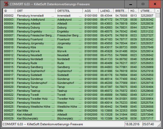
Screen Shot
Click on a thumbnail for the larger image.
System Requirements
Geodaten Deutschland requires WinXP, WinVista, WinVista x64, Win7 x32, Win7 x64, Win2000, WinOther, Mac OS X, Windows2000, Windows2003, WinServer, Windows Vista Ultimate, Windows Vista Ultimate x64, WinMobile, Windows CE, Android, BlackBerry, Palm OS 6.0, Win98, WinME, WinNT 3.x, WinNT 4.x, Win95, Unix, Linux, Handheld, Mobile Other, Java, Win 3.1x, Windows Tablet PC Edition 2005, Windows Media Center Edition 2005, Windows Vista Starter, Windows Vista Home Basic, Windows Vista Home Premium, Windows Vista Business, Windows Vista Enterprise, Windows Vista Home Basic x64, Windows Vista Home Premium x64, Windows Vista Business x64, Windows Vista Enterprise x64, Windows Mobile 2003, Windows Mobile 2005, MS-DOS, OS, 2, Windows 8, Windows Phone 7, Windows Phone 8, Windows RT, Windows Server 2012.
Geodaten Deutschland v.18.01 Copyright
Shareware Junction periodically updates pricing and software information of Geodaten Deutschland v.18.01 full version from the publisher using pad file and submit from users. Software piracy is theft, Using crack, password, serial numbers, registration codes, key generators, cd key, hacks is illegal and prevent future development of Geodaten Deutschland v.18.01 Edition. Download links are directly from our publisher sites. Links Geodaten Deutschland v.18.01 from Bittorrent, mediafire.com, uploadfiles.com, hotfiles.com rapidshare.com, megaupload.com, netload.in, storage.to, depositfiles.com and other files hosting are not allowed. The download file is obtained directly from the publisher, not from any Peer to Peer file sharing applications such as Shareaza, Limewire, Kazaa, Imesh, eDonkey, eMule, Ares, BearShare, Overnet, Morpheus, BitTorrent Azureus and WinMX.
Review This Software
More Geodaten Deutschland Software
Advertisement

Deutschland Radio v.4.5.155.0
More then 210 Deutschland Radio Stations (High-Band & Best Quality).* RSS feeds From Spiegel online, tagesschau.de, sueddeutsche.de and google News * Useful German Video and Media Links * Google Search , Wikipedia, Compare Prices * Torrent Search -

Geodaten International Admin
Geo data international world-wide with towns, town quarters and postal codes. Georeferences as UTM- and geographic coordinates (WGS84) and elevations. Suitable for branch searches, periphery searches and distance computations. Australia, Austria,

Geodaten German Admin
The database contain geodata of the Federal Republic of Germany with geo referenced towns, municipalities, town quarters, administrative units, postal codes, telephone preselections, nature areas, landscapes, climatic zones. The data contain coordinates
Geodaten German Streets
For the area of the Federal Republic of Germany more than 1.5 million street coordinates with a coverage of 100% are available. The geo data offered here are in high-precision quality and are present in several coordinate and reference systems.
Geodaten German Houses (deutsch) v.1.00
For the area of the Federal Republic of Germany more than 19 million house coordinates with a coverage of 100% are available. The geo data offered here are in high-precision quality and are present in different coordinate and reference systems.
Geodaten International Streets (Deutsch) v.1.00
For many countries street coordinates are present with coverage degrees upto 100 percent. The geo data offered here are in high-precision quality and are present in different coordinate and reference systems.

Geodaten International Houses (English) v.1.00
For many countries house coordinates are present with coverage degrees upto 100 percent. The geo data offered here are in high-precision quality and are present in different coordinate and reference systems.

Geodaten International Houses (deutsch) v.1.00
For many countries house coordinates are present with coverage degrees upto 100 percent. The geo data offered here are in high-precision quality and are present in different coordinate and reference systems.

Geodaten German Streets (deutsch) v.1.00
For the area of the Federal Republic of Germany more than 2,7 million street coordinates with a coverage of 100% are available. The geo data offered here are in high-precision quality and are present in different coordinate and reference systems.

Geldautomaten in der Nähe Deutschland v.1.1.0.0
Mit Geldautomaten in der Nähe finden Sie immer den nächsten Geldautomat – und zwar nicht irgendeinen, sondern den nächstgelegenen Ihrer Bank oder Bankgruppe, bei dem Sie ohne Gebühren abheben können. Die klassische Situation: Sie sind

Geodaten International v.6.01
Geodata International - World-wide database of countries with georeferenced towns, municipalities, postal codes and administrative units with WGS84 and UTM coordinates and elevations for geocoding, proximity search, navigation, distance calculation.
Other products of this developer C. Killet Software Ing.-GbR

CONVERT v.6.07
The freeware program CONVERT from KilletSoft con...import of the data in any DBMS will be possible.
CONVERT (Deutsch) v.1 3
The freeware program CONVERT converts any dBase ...GbR as dBase tables into different data formats.
CONVERT (English) v.1 3
The freeware program CONVERT converts any dBase ...GbR as dBase tables into different data formats.

CONVERT Deutsch v.4.01
The freeware program CONVERT from KilletSoft con...import of the data in any DBMS will be possible.

CONVERT English v.401
The freeware program CONVERT from KilletSoft con...import of the data in any DBMS will be possible.

DRAGSENS English v.1.20
DRAGSENS Geo Software is used for the exact posi... estimation of the position of a dragged sensor.

Geo Data German Admin v.15.00
The database contain geodata of the Federal Repu...capes, climatic zones for proximity searches ec.
Geo Data German Admin (English) v.10 2
Geodata of the Federal Republic Germany with mun...Krueger, UTM and geographic coordinates. ORTREF:
Geo Data German Houses
For the area of the Federal Republic of Germany ...in several coordinate and
reference systems.
Geo data German Streets (English) v.1.00
For the area of the Federal Republic of Germany ...t in different coordinate and reference systems.